Long day for Ida

For the next bit I was planning a 25 mile day.

I get up, get moving and remember tropical storm Ida is coming today/tomorrow.

When I checked weather, maybe some non-ida showers during the day with Ida bringing late day t-storms. Well, there are no great trail exits, and there is a bridge out on a creek which means a fording. After that there is a shelter and shortly further a hostel.
I think it’s doable but man I’d like to be in a hard wall thing for any t-storms.

A seasoned hiker"pi" once told me that sometimes hiking fast is safer. I think in this case it’s true.
So even though I hiked 25 miles yesterday I put on my big boy shorts and pedal-down.
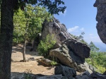
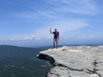
There is a lot of elevation change in the hike. Others would refer to this as PUD or pointless up and downs. There were few views, and a ~16 mile stretch without water.

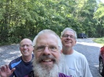
I ran into a North bound flip flopper who was 300 miles from finishing. That was cool.

Just after meeting him I had to prep for the the long dry stretch so I drank the 2 liters I had and filled up.

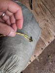
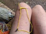
About 15 mins later I got stung by something (wasp/yellow jacket/hornet) 3 times quickly…

It started misty raining but honestly I was sweating so much it didn’t make me wetter.

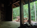
I made it to a shelter at mile 17. With 8 left to go… When the rain picked up a bit.
I stayed in the shelter and snacked while the initial wave calmed. It was at the very top of the mountain. Not ideal for thunderstorms.

So,it was About 1pm and I had 6 miles mostly downhill to the fording, 8 miles to end the day, and the updated forecast showed rain in earnest about 5pm. Thus far my shoes and socks were still dry. I was a little worried that the fording could get bad with Ida rains.

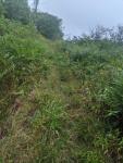
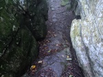
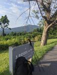
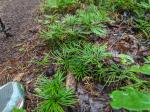
So, I put on my rain hat and started the downhill. The hat kept my head dry but there was a ton of grass which soaked my feet. Well, I was committed. I kept thinking I’d get back to deep woods but there was about 2 miles of tall grass on the Ridgeline (pic included). It would not be ideal to get lightening here. Oof. Eventually it yielded to forest again.

I burned down the ridge in just a little over 2 hours.
The fording was nothing so I’m glad I did it before Ida came through.
I stopped 1/2 mile shy of the shelter to get water. After filtering a liter the rain started increasing so I packed 2 dirty waters and burned up the hill to the shelter.

It looks like I’ll have it to myself tonight. All is well that ends well.
24.6 miles
7.1k up
6.8k down

Next morning it clears a bit so I go uphill for cell service….oof clouds coming on radar.
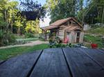
I hot foot it to a hostel…and get caught in it.

2 miles
1.2k up
1.4k down
Derp nero

Leaving Pearisburg. And a milestone

Good morning, campers!
I heard from 3 different sources over the last few days that I should stop at Wood’s hole hostel.
I hemmed and hawed at myself because it’s only 12 miles ish down the trail, but decided to check it out anyway. The place is a really cool remote venue right near the trail. Dinner was a from-garden-pizza and a from-garden salad. All fresh and tasty!
I’m staying in the bunkhouse which is really pretty neat. It’s an old log cabin and most of the bunks are in the rafters. The downstairs is a common area. We ate on the main house front porch (also a log cabin). The picture is of the bunk house from the front porch.

I was here by noon and had a nice afternoon of reading and enjoying the cool rustic calm vibe. I plan to hit the trail harder the next day.

The trail had quite a bit of overgrown weeds but was still pretty fast.
12 miles
3.7k up
1.9 down
I thought a harder next day will catch me up.

It turns out that was not to be…
I had hiked ~17 miles and thought a cold drink and second lunch sounded good. At a road crossing I headed up to Trent’s grocery… a known stop….about 1/2 mile up a road walk. When I started digging in my pack I realized my wallet wasn’t there. I always carry a little something green somewhere else in my pack so grabbed that and was going to get a cold drink while I ponder my fate. Turns out Trent’s is closed on Sundays…and guess what day it is!

So, hot, unsatisfied, I check what else is nearby. It turns out there is a hostel very close. It’s about 1/2 mile the other direction.
So I head that way. While walking, I start digging up the hostel phone # but before I get it dialed, the hostel owner sees me beside the road and offers me a ride!

I have very high suspicion that I left my wallet in the loaner shorts I was wearing at the last hostel while I was doing laundry… so I reach out to the hostel owner from the previous night.
BINGO!
After arranging for a shuttle driver to pickup/deliver my wallet it looks like it’ll be pretty late to pick back up hiking today.
So, it looks like I’m staying here at "Weary feet" tonight and resuming tomorrow!

16 miles
2.2k up
3.4k down

Next day I made up some of the miles. Very humid but cooler. My dogs are barking.
Almost 7k up
I saw many deer. I had to stand 20′ away and shoo a 4 pt buck off the trail. No spectacular photos that day but I did eat hot food at lunch which I prepped and a burger and fries for dinner at bush mountain outpost!

25.2 miles
6.8k up
6.4k down

Completed 1600 miles!

I think 1 more hard day and then a cruise into Atkins before sprinting to Damascus.

Or maybe the remnants of ida will intervene.

Headed to Pearisburg!

Goldie drops me at the trailhead and I’m off to the races. I’m about a day past Daleville and I have a package coming to a hostel in Pearisburg.

I plan to zero in Pearisburg as it’ll be something like 7 trail days in a row and I need to deal with stuff coming in the packages. I have spent 2 nights off trail but was back on trail the next mornings…

I hiked dragons tooth today. I didn’t climb the tooth. Not my kind of thing. Was still pretty cool. With limited water I could either go 14 or 20. Was feeling good and 14 happened early, so opted for 20. Disperse camped right by the creek at dusk. I took more breaks to cool off during the day.
20.9 miles
5.9k up
6.3k down

I passed another milestone 1500 miles!

Pounded more miles on the trail. Super hot and water is scarce. I stayed at a dispersed site near a creek that was spacious and nice.

20 miles
5.4k up
5.0 k down

This was some tougher hiking today. Not from elevation or distance! It was the most rocky I recall in VA. It also needed a lot of trail grooming. Blown down trees and tall weeds were all in my business.
19.8miles
5.6k up
4.2k down

Finally, into Pearisburg! Rain forecasted so I got up early and hustled to town.
Got into town in time to get a few errands done. Will zero tomorrow.
13.5 miles
2.2k up
4.0k down

Crazy day

The astute will remember that at one time I hiked with Goldie. He was a nobo but now he’s done and rejoined society… except for when he reached back into the hiking world and offered up an oasis from the trail for a night at his sister’s place! I offered up some jambalaya!

All I had to do was get to the parking lot about 3:30.

It’s about 20 miles and that’s pretty early…

So I start early and keep the foot mostly on the gas…but there are some seriously cool things this day!
– Tinker cliffs
– McAfee knob

It starts out foggy but I’m on a mission.
As I come up on Tinker cliffs my sister in law (my wife’s younger sister) texts me and asks where I am….whuuuut?

It turns out she is not terribly far away and wanted to see me in person. Well heck yeah! So I persuaded my sis in law to join us at goldie’s sister’s place for jambalaya and Goldie and his sister were gracious enough to let her come by! So now I really need to be on time!

Long story short, I burned 20 miles in 9 hours, with almost 6k up, met Goldie, resupplied, went swimming in the pool, made dinner, enjoyed some fabulous fellowship with Goldie, his sister, his daughter, and my sister in law.

Oh, and there was a snek in a shelter I took a break in….

20.5 miles
5.9k up
6.3k down

Into daleville

From thunder ridge to boppet’s gap shelter…started the morning in the misty rain breaking camp with a headlamp. There was a cool tunnel I took a picture of. Stayed damp almost all day. Had dinner early…thunder showers were threatening and there was a nearby shelter so I tucked in and made dinner. The showers surprisingly just dissipated.

23.6 miles6.1k up
8.0k down
Most elevation up+down in near highest miles. Somewhere in there I took a few hours helping a fella get his stuff back!

I wake up the next morning… Weather report says no rain (6%)…RADAR shows nothing…and it’s actively raining.
I want a job where I can be that wrong and it’s considered part of the job… Sheesh.

After being damp for the better part of 3 days I decided to grab a cheap hotel in Daleville. It was cheap. It was a hotel. It allowed me to dry out. It had a laundry. The best thing was that there was a decent Mexican-american food place across the street. Bottomless chips and salsa is hard when put in front of a hiker…because then you have to test it!

Boblett’s gap to Daleville
19 miles
4.7k up
5.7k down

Never too dull on the trail…

You may think the trail gets super boring. To be perfectly honest it can be. Today wasn’t that.I plan to meet a buddy in a few days and I have some trail miles to burn…so I woke up this morning with a fire in my belly and sticks in my hands.

I met a couple of fellows about 10 miles into the day and we chatted for a few minutes. They were from Illinois on a day hike.

A few miles later I find a wallet and cell phone in a baggie. I take a peek…the dl shows Illinois and it’s clear from the condition (it rained and the baggie was dry):that it’s from today.

So I had some options:
– chase them down (I’m faster but I don’t know where they might turn off)
– go on a bender
– figure out another way to get their stuff back to them

I went with the third option. They mentioned starting at Jennings creek. It was about 1.5 hrs away. I used Google to figure out my county and looked up the sheriff’s office. After a couple of minutes of chatting with the sheriff’s office we decided I would meet a deputy at the Jennings creek trailhead. I push the gas pedal and hike.

At the parking lot I find an Illinois tag car. Bingo!

The deputy shows, I give him the goods and we chat for a few. He says he’ll leave a note on the windshield, and goes to run plates as I finish up snacking and getting water.

As I’m getting up to leave someone pulls in. It’s the owner of the goods and his hiking partner!

It was great to get a happy ending!

The good looking feller in the middle is me. The one to the left of me is the guy with morning dropsies.

Now if I can avoid the rain and still get miles in that would be a great end to the day!

South of glasgow. Mistakes were made

Headed to Daleville.

I crossed thunder ridge today.
I didn’t see a single tauren
I did jump 4 grouse and had a deer stare at me from 20 feet away.

I hiked a shorter distance overall today but that elevation was a bugger.
15 miles
6.0k up
2.7k down
The last half mile was in rain. I dashed into the shelter and let it run it’s course.

Water is still scarce but better. Some sources reported as dry are at least scoopable.

Was about to set up was when’s I noticed something was missing. My tarp ridgeline!

While I was taping up the leaking seam of the tarp while zeroing I must have set it somewhere. 2 steps forward, 1 step back. I was able to cobble a line together from parts my wife sent for another fix and from a spare stake line. It seems to be holding this far but it’s definitely fragile.

For my ridgeline I use 2 hardware bits. One tree end I just use the hardware hook and loop the tree. The other end I add a loop in the line. I put a second bit of hardware on a small continuous loop and tie a prusik hitch along the line. The loop end goes around the tree and is secured (and adjusted with) the prusik hitch.

I added pictures of the first end and the loop before tying the prusik.

Of course it was too short so I used a stake line to extend the length. The stake line had 2 hooped ends and I just used a larkshead knot to join it to the hoop end of the jiggered Ridgeline.

Back in action!

A milestone!

1400 miles!
I’m taking a zero in Glasgow and planning forward a bit.
I have 3-4 days to Daleville then a few classics of the trail are coming up!
McAfee knob
Dragons tooth
Tinker cliffs

Maybe 3 more weeks in VA

Rumor is that water is scarce. Hopefully the rain over the last few days gets water sources going!

Soon I’ll get to see a fellow hiker "Goldie" who just completed a NOBO a few weeks ago! We met in PA and hiked together for a bit. He is setting me up for some trail magic and a break at Daleville!

Differences in the south end

The trail is substantially different in the south half. It’s true for a variety of reasons and I’ll list here some of my observations…

– Difference in the mountains (less rocky)
* More sections of clay not just rock and tree debris
* Fewer streams, more reliance on springs (could just e my perception)
– Difference in the trail
* More (any?) switchbacks
* Smoother trail (much of SNP construction was CCC projects not volunteers)
* More hardwoods and fewer conifers
– Difference in the hikers
* NOBOs are mostly gone
* SOBOs aren’t here yet (only really fast ones)
* Flip floppers are spread out a lot
* Mostly I see day/ section hikers
– Difference in the weather
* The thunderstorms are more severe
* Hot hot hot
– Flora is different
* More old hardwood canopies
* Blackberries instead of blueberries
– Differences in bugs
* More horseflies and deer flies
* Cicadas are here!
* Chiggers! Yuck!
– Fauna differences
* No moose
* More bears (I’ve seen 2 since starting VA)
* Poisonous snakes are back
* The early morning birds are less noisy…(unless there is a whippoorwill around)

I’ve also seen many more songbird feathers on the trail. I’m not really sure about the reason for that.

It’s still a physical challenge!
I’m sure I’ll see more changes as I hike.

Happy trails!

Three ridges and the priest

The subject line sounds like a joke but they are the section of trail I’m on at the moment. 🙂Im not doing as many miles but combining the priest on top of three ridges would be tough Three ridges:
16.7miles
3.8k up
5.5k down

There is a pic of three ridges before I climbed it. 3 ridges mountain is just above the sign.

At the end of that day I camped about 1/10 mile up the priest climb. The priest climb is about 3k feet up over 5 miles.
Rain was likely at 3 pm so I set up camp early. It ended up raining from 5pm until about 1am

After the climb up to the priest shelter I felt pretty good so I hiked a couple of extra miles past my plan

14.9 miles
5.9k up
3.9k down

Any additional miles would increase altitude and nearly 6k up was enough
I think my ankle is 100% now. Took no vitamin I and it still feels ok with no discernable swelling.

I skipped Buena Vista and am headed to Glasgow.

The next day was eventful:
– it rained all morning
– there was a lot of limbs from the previous night. Many I cleared from the trail
– one limb apparently had a wasp or hornet nest. I got hit once
– Goldie is trying to organize some trail magic!
– I met another flip flopper on the flop! (Daybreak). I think they may not be moving as fast though
– at lunch I slipped into a shelter to dry out a bit and just stayed there for an hour until the rain stopped. Twas quite nice!
– it rained on and off after I got my hammock up.
– My tarp has developed a (tiny) leak! Will have to deal with it in town
– the rain stopped around midnight
– added a pic of a weird groundcover I saw

20 miles
5.5k up
6.2k down

Heading into town…Glasgow, VA
11miles
2.4k up
4.2k down
So balmy….so wet. Remnants of tropical storm Fred are coming. Likely zero inn Glasgow to avoid more wet.

Design a site like this with WordPress.com
Get started